


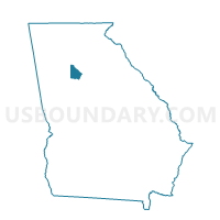
089FK - FLAKES MILL FIRE Voting District, DeKalb County, Georgia
About
Outline

Summary
| Unique Area Identifier | 561108 |
| Name | 089FK - FLAKES MILL FIRE Voting District |
| County | DeKalb County |
| State | Georgia |
| Area (square miles) | 1.66 |
| Land Area (square miles) | 1.66 |
| Water Area (square miles) | 0.00 |
| % of Land Area | 99.86 |
| % of Water Area | 0.14 |
| Latitude of the Internal Point | 33.64577800 |
| Longtitude of the Internal Point | -84.23920440 |
Maps


Graphs
Select a template below for downloading or customizing gragh for 089FK - FLAKES MILL FIRE Voting District, DeKalb County, Georgia


Neighbors
Neighoring Voting District (by Name) Neighboring Voting District on the Map
- 089HH - NARVIE J HARRIS Voting District, DeKalb County, GA
- 089KD - ML KING JR HIGH Voting District, DeKalb County, GA
- 15146 - SHAKERAG Voting District, Henry County, GA
- 15147 - ELLENWOOD Voting District, Henry County, GA
Top 10 Neighboring County Subdivision (by Population) Neighboring County Subdivision on the Map
Top 10 Neighboring Unified School District (by Population) Neighboring Unified School District on the Map
Top 10 Neighboring State Legislative District Lower Chamber (by Population) Neighboring State Legislative District Lower Chamber on the Map
Top 10 Neighboring State Legislative District Upper Chamber (by Population) Neighboring State Legislative District Upper Chamber on the Map
Top 10 Neighboring 111th Congressional District (by Population) Neighboring 111th Congressional District on the Map
Top 10 Neighboring Census Tract (by Population) Neighboring Census Tract on the Map
- Census Tract 234.19, DeKalb County, GA (8,851)
- Census Tract 701.07, Henry County, GA (7,009)
- Census Tract 701.08, Henry County, GA (5,393)
- Census Tract 234.22, DeKalb County, GA (5,156)